
Model Output File Format Description
Model output files should be in ASCII text format. Each file size should not exceed 1Mb. Full path name to the input file at your local disk should not contain any blank spaces or quotation marks. On DOS/Windows systems the recommended extension for the input file name is "txt".
The following file formats for model outputs for different physical parameters studies are expected:
Ionosphere/Thermosphere models or coupled model components:
TEC from ground-based GPS in eight 5° geographic longitude sectors
Year DOY Hour Min Sec Lat Lon TEC[TECU]
Here DOY is day of year, and TEC is Total Electron Content [TECU] at Lat + 2.5 [deg] and Lon + 2.5 [deg]. Lat and Lon are geographic latitude and longitude that correspond to first latitude and first longitude of the bin for measurement data to be compared with. Hour, Min and Sec also correspond to first Hour, Min, and Sec of the temporal bin for measurement data to be compared with.
TEC modeled value will be compared with GPS TEC measurement, which is median value over 15-min temporal bin (e.g., 00:00:00-00:15:00) and 5° lat x 5° lon spatial bin (e.g., -90°~ -85° lat and 25°~30° lon).
Click here to view the FORTRAN statement to write the required format.
NmF2 from COSMIC in eight 5° geographic longitude sectors
Year DOY Hour Min Sec Lat Lon NmF2[cm-3]
Here DOY is day of year, and NmF2 is maximum electron density at Lat + 2.5 [deg] and Lon + 2.5 [deg]. Lat and Lon are geographic latitude and longitude that correspond to first latitude and first longitude of the bin for measurement data to be compared with. Hour, Min and Sec also correspond to first Hour, Min, and Sec of the temporal bin for measurement data to be compared with.
NmF2 modeled value will be compared with COSMIC NmF2 measurement, which is median value over 15-min temporal bin (e.g., 00:00:00-00:15:00) and 5° lat x 5° lon spatial bin (e.g., -90°~ -85° lat and 25°~30° lon).
Click here to view the FORTRAN statement to write the required format.
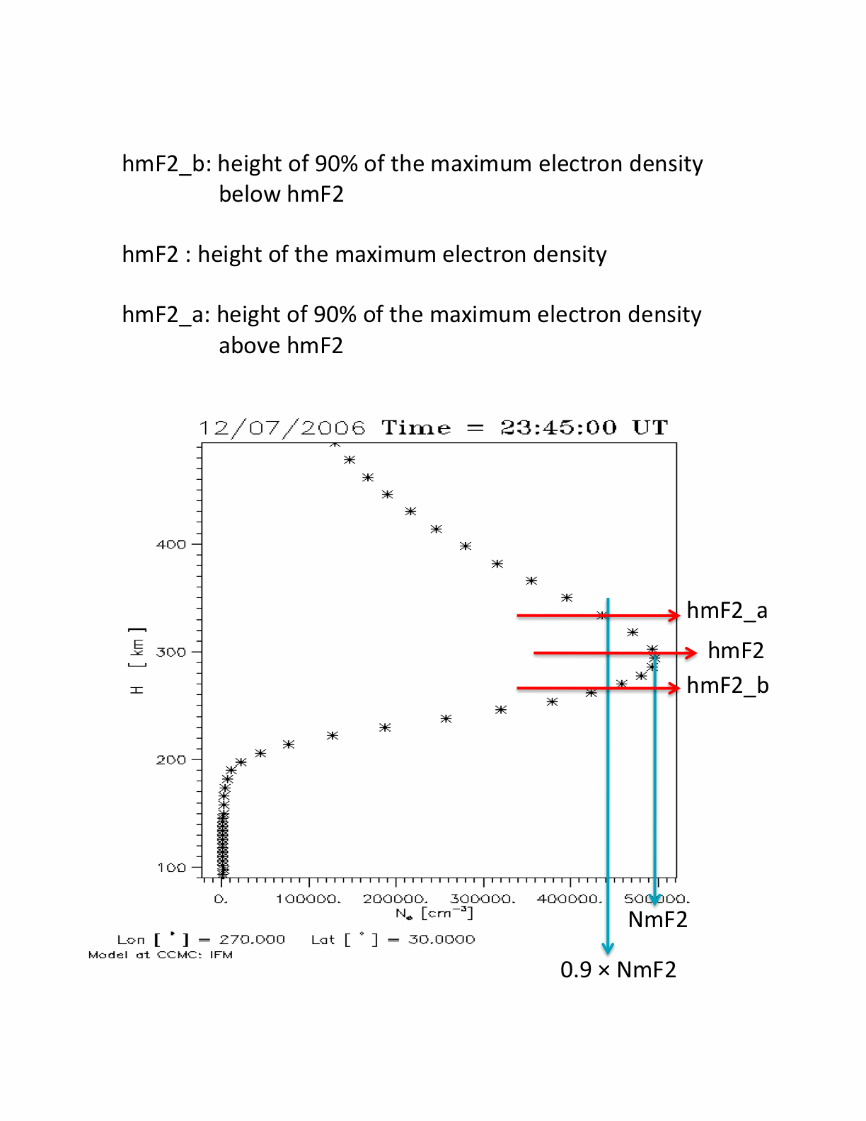
hmF2 from COSMIC in eight 5° geographic longitude sectors
Year DOY Hour Min Sec Lat Lon hmF2[km] hmF2_a[km] hmF2_b[km]
Here DOY is day of year, and hmF2 is height of maximum electron density at Lat + 2.5 [deg] and Lon + 2.5 [deg]. Lat and Lon are geographic latitude and longitudethat correspond to first latitude and first longitude of the bin for measurement data to be compared with. Hour, Min and Sec also correspond to first Hour, Min, and Sec of the temporal bin for measurement data to be compared with.
As optional parameters, hmF2_a and hmF2_b are height of 90% of the maximum electron density above hmF2, and below hmF2, respectively.
hmF2 modeled value will be compared with COSMIC hmF2 measurement, which is median value over 15 min temporal bin (e.g., 00:00:00-00:15:00) and 5° lat x 5° lon spatial bin (e.g., -90°~ -85° lat and 25°~30° lon).
Click here to view the FORTRAN statement to write the required format.
Vertical and horizontal drifts at Jicamarca (VperpN and VperpE)
Year DOY Hour Min Sec Lat[deg] Lon[deg] Height[km] VperpN[m/s] VperpE[m/s]
Here DOY is day of year, andVperpN is vertical drift [m/s] and VperpE is horizontal drift [m/s] toward the east at Jicamarca (Lat[deg], Lon[deg]) at 155 km height. Lat and Lon are geographic latitude and longitude.
Neutral density at CHAMP orbit (Nden)
Year DOY Hour Min Sec Lat[deg] Lon[deg] Height[km] Nden[kg/m3]
Here DOY is day of year, andNden is neutral density [kg/m3] at CHAMP position (Lat [deg], Lon [deg], Height [km]. Lat and Lon are geographic latitude and longitude.
Electron density at CHAMP orbit (Eden)
Year DOY Hour Min Sec Lat[deg] Lon[deg] Height[km] Eden[1/cm3]
Here DOY is day of year, andEden is electron density [1/cm3] at CHAMP position (Lat [deg], Lon [deg], Height [km]). Lat and Lon are geographic latitude and longitude.
NmF2 from LEO satellites (CHAMP and COSMIC) and ISRs
Year DOY Hour Min Sec Lat[deg] Lon[deg] NmF2[1/cm3]
Here DOY is day of year, andNmF2 [1/cm3] is maximum electron density from either LEO satellites or ISRs. Lat [deg] and Lon [deg] for NmF2 from ISRs are geographic latitude and longitude of ISRs. For NmF2 from LEO radio occultation measurements, Hour, Min, Sec, Lat [deg] and Lon [deg] are universal time and geographic location at which maximum electron density occurs that are not on the satellite track.
Please use information from this table to extract the maximum location and time.
HmF2 from LEO satellites (CHAMP and COSMIC) and ISRs
Year DOY Hour Min Sec Lat[deg] Lon[deg] HmF2[km] HmF2_a[km] HmF2_b[km]
Here DOY is day of year, and HmF2 [km] is height of maximum electron density from LEO satellites or ISRs. HmF2_a and HmF2_b are height of 90% of the maximum electron density above HmF2, and below HmF2, respectively. Lat [deg] and Lon [deg] for NmF2 from ISRs are geographic latitude and longitude of ISRs. For NmF2 from LEO radio occultation measurements, Hour, Min, Sec, Lat [deg] and Lon [deg] are universal time and geographic location at which maximum electron density occurs that are not on the satellite track.
Please use information from this table to extract the maximum location and time.
Temperature Tn obtained by Fabry-Perot Spectrometer at 250 km (Arrival height, Antarctica; Resolute Bay, Canada)
Year DOY Hour Min Sec Lat [deg] Lon[deg] Height[km] Tn[K]
Neutral temperature Tn at 250 km height obtained by the Fabry-Perot Spectrometer at Arrival heights, Antarctica (only for E.2005.190 event) and Resolute Bay, Canada (only for E.2006.348 event)
Here DOY is day of year, and Hour, Min, Sec are universal time. Height[km] is 250 km which corresponds to the emission peak for atomic oxygen red line (630 nm). Tn[K] represents neutral temperature in kelvin. There are measurements from 5 observation look directions at Arrival heights the geographic locations (lat, lon) become
- N (-72.60, 166.67)
- W (-77.83, 142.62)
- S (-83.06, 166.67)
- Z (-77.83, 166.67)
- E (-77.83, 190.72).
- N (76.98, -94.89)
- W (74.73, -103.42)
- S (72.48, -94.89)
- Z (74.73, -94.89)
- E (74.73, -86.36)
View sample file for Tn from eastward direction (E) at Arrival heights during E.2005.190 event.
Neutral winds obtained by Fabry-Perot Spectrometer at 250 km (Arrival height, Antarctica; Resolute Bay, Canada)
Year DOY Hour Min Sec Lat [deg] Lon[deg] Height[km] Un[m/s] Vn[m/s] Wn[ms]
Here Un[m/s], Vn[m/s], and Wn[m/s] are zonal, meridional , and vertical winds, respectively. Un is positive eastwards, Vn is positive northwards, and Wn is positive upwards.
View sample file for winds from eastward direction at Arrival heights during E.2005.190 event.
Ne at 300 km (Millstone Hill, Sondrestrom, EISCAT, Svalbard ISRs).
Year DOY Hour Min Sec Lat[deg] Lon[deg] Height[km] Ne[1/cm3]
Here DOY is day of year, and Ne is electron density [1/cm3] at 300 km height. Lat [deg] and Lon [deg] are geographic latitude and longitude of ISRs.
Ne at 300 km rom ISRs:
- Millstone Hill(42.62, -71.49),
- Sondrestrom(66.99, -50.95) ,
- EISCAT (69.58, 19.23),
- EISCAT Svalbard (78.1, 16.05)
View sample file for Ne from Millstone Hill ISR during E.2006.348 event.
Te at 300 km (Millstone Hill, Sondrestrom, EISCAT, Svalbard ISRs).
Year DOY Hour Min Sec Lat[deg] Lon[deg] Height[km] Te[K]
Here DOY is day of year, and Te is electron temperature [K] at 300 km height
Te at 300 km rom ISRs:
- Millstone Hill(42.62, -71.49),
- Sondrestrom(66.99, -50.95) ,
- EISCAT (69.58, 19.23),
- EISCAT Svalbard (78.1, 16.05)
View sample file for Te from Millstone Hill ISR during E.2006.348 event.
Ti at 300 km (Millstone Hill, Sondrestrom, EISCAT, Svalbard ISRs).
Year DOY Hour Min Sec Lat[deg] Lon[deg] Height[km] Ti[K]
Here DOY is day of year, and Ti is ion temperature [K] at 300 km height
Ti at 300 rm from ISRs:
- Millstone Hill(42.62, -71.49),
- Sondrestrom(66.99, -50.95) ,
- EISCAT (69.58, 19.23),
- EISCAT Svalbard (78.1, 16.05)
View sample file for Ti from Millstone Hill ISR during E.2006.348 event.
Ion vertical velocity at Sonderstrom ISR
Year DOY Hour Min Sec Lat[deg] Lon[deg] Height[km] Wi[m/s]
Here DOY is day of year, and Wi[m/s] is ion vertical velocity at 300km height.